THE LONG WAY: OURAY 100
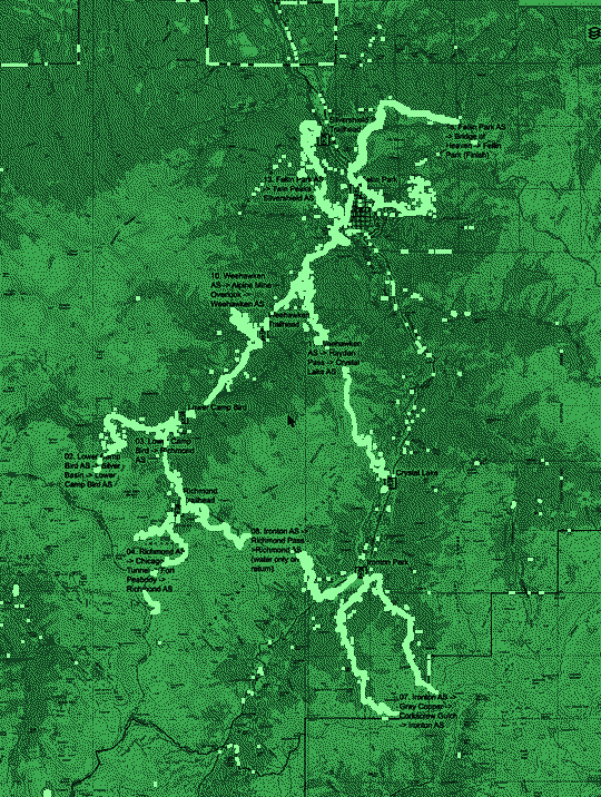
Map, elevation, route and aid stations.
- PARTY STATS
- Distance
- 102.1 miles
- Start
- 8am, Fri 7/16/27
- Finish by
- 12pm, Sun 7/18/27 (52 hours)
- Gain
- 41,862 ft
- Change
- 83,724 ft
- High
- 13,365 ft
- Low
- 7,640 ft
- Avg
- 10,239 ft
SURVIVAL ESSENTIALS
- Lights: headlamp (or waist lamp) and a backup light source. Required. Gear list
- Emergency kit: we give you a little ziplock bag (poncho, Mylar blanket, emergency flashlight, water treatment tabs, Bic mini lighter, tealight candle). Carry them the whole race. If you can't produce the baggie at a spot check, you are immediately disqualified.
- Lightning: DO NOT go above tree line if a storm is brewing. Wait it out below tree line. If a storm pins you down and you narrowly miss a cutoff, we are likely to give you some leeway. Lightning
- Parking: side roads (e.g. 8th Ave., 7th Ave., 2nd St.), where you can park for three days. Not overnight on Main Street, in the RV lot south of the gazebo, or in the hot springs lot. Parking
- Check-in: Fellin Park (look for a gazebo), 1220 Main St, Ouray, CO 81427. Ouray 100: early packet pickup Thursday, 7/15/27, 4:00 - 7:00 PM, or race day Friday, 7/16/27, 7:00 - 7:45 AM. Ouray 50: race day Saturday, 8/14/27, 10:00 - 11:45 AM. Schedule
- Pacers: For the 100, pacers are allowed beginning at mile 53.7 (Weehawken Aid Station to finish). Pacers must sign a waiver in order to be authorized on the course.
The Ouray 100 starts and finishes at Fellin Park, only yards from the hot springs. With over 40k feet of elevation gain, this is one of the most difficult 100 milers in the world.
THE ROUTE INCLUDES
- Fellin Park (start)
- Camp Bird Road
- Silver Basin
- Imogene Pass Road
- Chicago Tunnel
- Fort Peabody
- Ptarmigan Lake
- Richmond Trail
- Ironton
- Corkscrew Gulch
- Gray Copper Trail
- Weehawken Trail / Alpine Mine Overlook
- Hayden Trail / Crystal Lake
- Old Twin Peaks Trail
- Silvershield Trail
- Perimeter Trail / Lower Cascade Trail
- Chief Ouray Mine Trail
- Old Horsethief Trail / Bridge of Heaven
- Fellin Park (finish)
Listed as on the current site. This is a list of route features, not a turn-by-turn order. Use Section Descriptions and Race Flow for order and mileage.
ELEVATION

COURSE MAP
MAPS & DOCUMENTS
Aid station offerings · Wildlife · All rules
BEGIN JOURNEY >